Home to recreation, national forest land, and a scenic waterfall, the Fish Creek Basin in Steamboat Springs hosts a variety of interests and land uses. This project will explore the environmental history of Fish Creek and the relationship between the various land users.
USFS
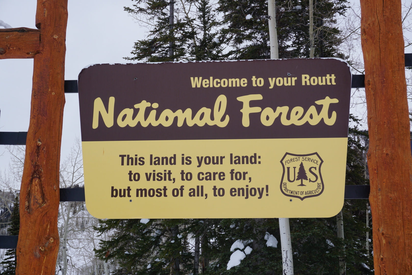
Fish Creek Basin is a part of the 2.9 million acres of the Medicine Bow- Routt National forest. This massive land area covers an expanse from Central Colorado all the way to northeastern Wyoming. One of the largest projects the USFS works on is managing the Mountain Pine Beetle infestation. Although the majority of Steamboat’s forests remain healthy, this is not the case for all of USFS managed land as 1.5 acres in Northern Colorado and Wyoming are affected by the infestation.

The USFS mission is to “support nature in sustaining life”. This mission differs greatly from the goal of uranium mining, which hoped to use a rural areas untapped resources to support a federal war effort. In order to accomplish this mission, the USFS is relatively hands-off in the Fish Creek Basin. The forest is allowed the space to grow and regenerate since the flow of tourists is relatively low in number and impact, in comparison to a national park’s visitor density.
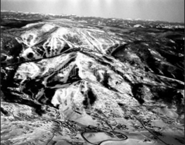
The USFS manages the Flat Tops range as well. The Storm Mountain district (which neighbors Fish Creek and is now known as Mt. Werner) and the Flat Tops range border the Yampa Valley, both rising above the river valley, effectively creating a basin. In this way, the USFS lands border the community of Steamboat Springs from the outside world.

My hikes in Fish Creek Basin have been a formative part of my experience with nature and my community. In a single hike, you can see Mt. Werner, Fish Creek Canyon, the Flattops, and the town of Steamboat. Because the trail has low foot traffic, it’s easy to come any time of day and enjoy the quiet perspective.
References:
“Mountain Pine Beetle Epidemic.” USDA Forest Service Website. Accessed 12/09/2019 https://www.fs.usda.gov/detail/mbr/home/?cid=stelprdb5139168.
“About the Agency.” USDA Forest Service Website. https://www.fs.fed.us/about-agency
“Medicine Bow- Routt National Forest: About Our Forests.” USDA Forest Service Website. https://www.fs.usda.gov/detail/mbr/home/?cid=fswdev3_008649
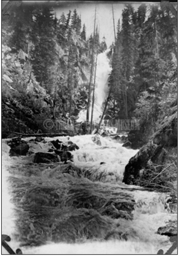
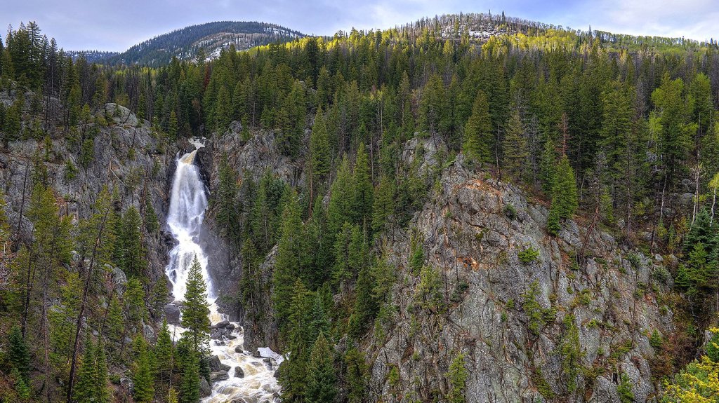
Recreation in Fish Creek Falls
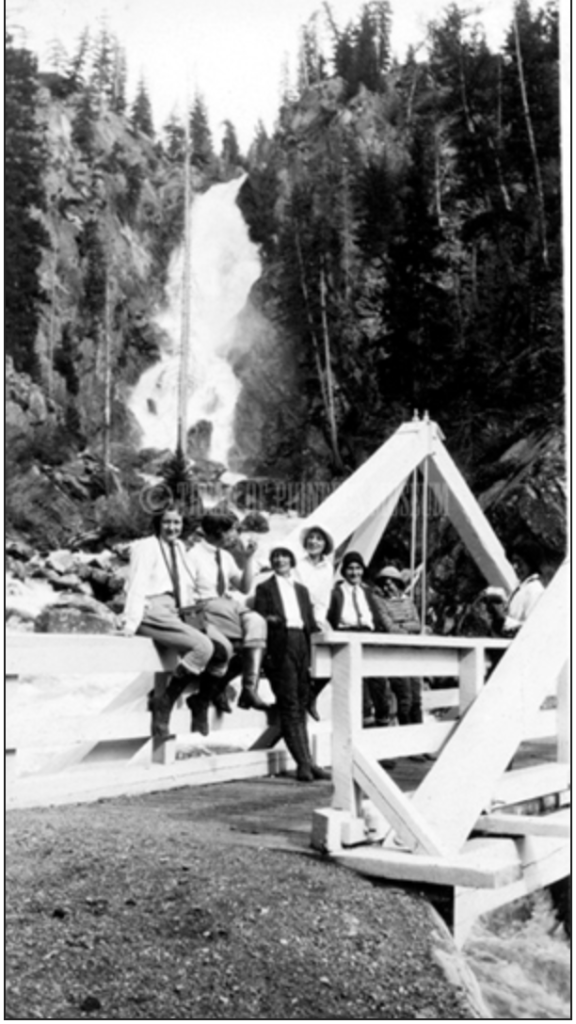
Today, Fish Creek is known for its recreation and accessibility. The main waterfall overlook trail is wheelchair accessible and features and educational tour of the flora and fauna of the region for hikers. Trail #1102 or the “Long Lake Trail” is the direct trail to the iconic bridge where hikers and kayakers alike meet to explore Fish Creek.
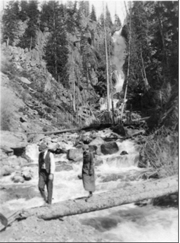
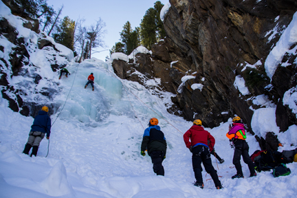
The Long lake trail is in the shaded side of the valley and zig zags up the mountain through a lodgepole pine forest before it reaches an elevation where Aspens are the dominant tree. In the winter months, hikers can look down upon ice-climbers climbing up the falls. Rescue groups practice emergency water rescues at the base of the falls. Across the glacial valley on the sun facing side is the Uranium trail, where hikers and rock climbers roam through the sage brush lined trail. This is a popular hiking destination but also a portal for locals that connects to a neighboring mountain, Mt. Werner, which hosts the Steamboat Ski Resort. Skiers who “duck” the boundary rope on the mountain can ski fresh powder and navigate the Fish Creek Canyon, and ski to the Forest Service Parking lot.
However, even though both areas are managed by the Forest Service, there is a tension between the USFS of Fish Creek and the Ski Patrol of Mt. Werner over rescue operations for ill fated skiers that chose to ski out of bounds. The area is a limbo for skiers because by ducking the boundary line, they are no longer Steamboat Ski Patrol’s responsibility. By trespassing in an area and originating from a foreign entity (not entering through the Fish Creek Forest Service entry) they are technically not the Fish Creek USFS responsibility. A few skiers have spent the cold winter night in Fish Creek due a lack of communication between rescue parties.
The development of recreation in Fish Creek Basin shows how far the area has evolved from a purely extractive source. The management of the land has shifted significantly due to the amount of varied and interested parties. Today over 50,000 people visit the hiking trails and waterfall overlooks. In order to visit Fish Creek Falls, visitors need to pay a $5 fee for day recreation. Parking ticket fees and day use fees go to maintaining the facilities: bathrooms, picnic areas, and ongoing trail restoration efforts in order for Fish Creek to continue to be managed for the next generations.
Mining in Fish Creek Canyon
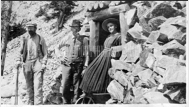
Uranium was discovered in the Fish Creek Canyon in 1952. The uranium bearing zones were between 1-20 feet long and 1000 feet in depth and contained about 0.3% uranium. Although the area is no longer mined, the USGS cites abnormal radioactivity in a half mile radius from the original site. Uranium is still mined globally today and in a recent report the U.S. Atomic Energy Commission advocates for additional prospecting in their 2010 report of the area, as few sites have been examined in detail.
Uranium became a highly lucrative element with the discovery of its role in nuclear weapons development. Routt County was not a part of South West Colorado’s Uravan Mineral Belt, which held dense uranium deposits, but it did participate in the federal government’s mining program during the Cold War. In 1948, the federal government encouraged citizens in rural areas to build roads into remote places rich in radioactive ore.
Upon discovery in 1947, Fish Creek Canyon became a short lived host for this endeavor. The Steamboat Pilot called Uranium “the most sought after and valuable metal in the world.” Unlike the coal mine industries in outside of the town of Steamboat Springs, the uranium industry was unsustainable.
Today the uranium mine is boarded up due to potential radioactive exposure and a sensitive bat habitat, but hikers can view the stalagmites and pools of ice through the grate. The rusted track used for transporting mined material is buried beneath tree roots and soil, but uproots in the small opening of the work area. In the sixty years since the mine has been fully operable, the remnants have almost entirely disappeared. The short-lived uranium economy in Steamboat Springs was just one example of the geological natural resources in the valley.

Although uranium mining hosts a wealth of health risks for miners, the mine closed down before the effects could harm the community in any significant way. The City of Steamboat’s water source is over a mile away from the original mine site, and The USGS monitors the quality of the water to ensure there is no radioactive material.
Now the “Uranium Trail”, which was an old Jeep Road for the mine site, is one of the valley’s most popular hikes. This connects to the rise of recreation in the Fish Creek Canyon and the role of the United States Forest Service in the land’s management, which will be covered in the next blog post.
References:
Beroni, E. P. (Ernest Pete), 1919-2001. Reconnaissance for Uraniferous Rocks in Northwestern Colorado, Southwestern Wyoming, and Northeastern Utah. Oak Ridge, Tennessee: U.S. Atomic Energy Commission, Technical Information Service, 1952.
“Uranium Deposit Reported Found in Routt County,” The Steamboat Pilot, October 16, 1947, https://www.coloradohistoricnewspapers.org/?a=d&d=STP19471016.2.3&srpos=6&e=——-en-20–1–img-txIN%7ctxCO%7ctxTA-uranium——-0-Routt-.
Geologic History
Fish Creek Canyon is a glacial valley that rests in the Routt National Forest territory of the Park Range in Steamboat Springs, CO. The modern streams in the valley, the Fish Creek and the North Fork Fish Creek flow from Long Lake, a glacial lake located 5 miles from the start of the USFS trailhead. The glacial sediment formed from the erosion updip and deposition downdip gives the creeks a foundation of hard rock material. The sedimentary deposits surround much of the basin and are tell tale signs of a glacial deposit. The waterfall, an iconic tourist destination is categorized as a “hanging valley” that contributed to the main glacial valley.
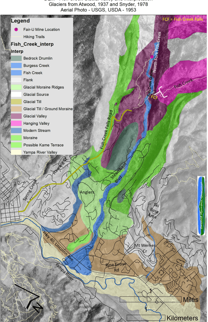
The U-Shaped valley differs from a river carved V-Shaped valley. The glacial scouring of the Fish Creek valley left a large trail of geologic material, some small boulders line the creek bed as modern day evidence of the valley formation. The glacial formation was not limited to the Fish Creek Basin as much of the Yampa Valley’s water sources come from previous glacier valleys.
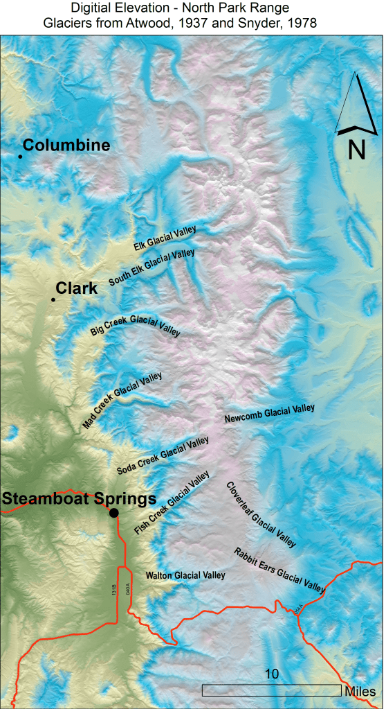
The Fish Creek Glacial Valley can be seen above with the Soda Creek, Mad Creek, and South Elk Glacial Valleys; all which remain a water source for recreation and ranching. The Fish Creek valley is unique because the oxidized groundwater led to a unique phenomena in Routt County. The surface rocks, left behind from the glaciation period, leached uranium into fresh water aquifers. There, the uranium reduced to precipitate uraninite, considered the primary ore mineral of uranium.
The history of uranium will be covered in the next blog post!
References for this post:
“Fish Creek Glacial Valley,” Emerald Mountain Geoscience, March 8, 2019, http://emerald-mtn-geo.com/steamboat-springs-geology-tidbits/fish-creek-glacial-valley/.
“Digital Elevation North Park Range,” Fish Creek Falls- Steamboat and North Park Mountain Range Glacial Topography, Emerald Mountain Geoscience, last modified April 17, 2019, http://emerald-mtn-geo.com/steamboat-springs-geology-tidbits/fish-creek-falls-steamboat-and-north-park-mountain-range-glacial-topography/.
“Fish Creek Falls Hiking Trails,” Alterra Mountain Company, December 2019, https://www.steamboat.com/things-to-do/activities/hiking/fish-creek-falls.
“What is Uranium?” World Nuclear Association, August 2019, https://www.world-nuclear.org/information-library/nuclear-fuel-cycle/introduction/what-is-uranium-how-does-it-work.aspx#.UchZ6Vb_KrQ
